Combined UAVSAR and GPS Estimates of Fault Slip for the M 6.0 South Napa Earthquake
Abstract:
Andrea Donnellan, Jay Parker, Brian Hawkins, Scott Hensley, Cathleen Jones, Susan Owen, Angelyn Moore
Jet Propulsion Laboratory, California Institute of Technology
Marlon Pierce, Jun Wang
Indiana University
John Rundle
University of California, Davis
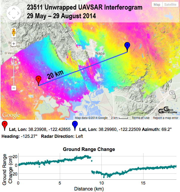
The South Napa to Santa Rosa area has been observed with NASA’s UAVSAR since late 2009 as part of an experiment to monitor areas identified as having a high probability of an earthquake. The M 6.0 South Napa earthquake occurred on 24 August 2014. The area was flown 29 May 2014 preceeding the earthquake, and again on 29 August 2014, five days after the earthquake. The UAVSAR results show slip on a single fault at the south end of the rupture near the epicenter of the event. The rupture branches out into multiple faults further north near the Napa area. A combined inversion of rapid GPS results and the unwrapped UAVSAR interferogram indicate nearly pure strike slip motion. Using this assumption, the UAVSAR data show horizontal right-lateral slip across the fault of 19 cm at the south end of the rupture and increasing to 70 cm northward over a distance of 6.5 km. The joint inversion indicates slip of ~30 cm on a network of sub-parallel faults is concentrated in a zone about 17 km long. The lower depths of the faults are 5-8.5 km. The eastern two sub-parallel faults break the surface, while three faults to the west are buried at depths ranging from 2-6 km with deeper depths to the north and west. The geodetic moment release is equivalent to a M 6.1 event. Additional ruptures are observed in the interferogram, but the inversions suggest that they represent superficial slip that does not contribute to the overall moment release.