Rapid Response Products of The ARIA Project for the M6.0 August 24, 2014 South Napa Earthquake
Rapid Response Products of The ARIA Project for the M6.0 August 24, 2014 South Napa Earthquake
Abstract:
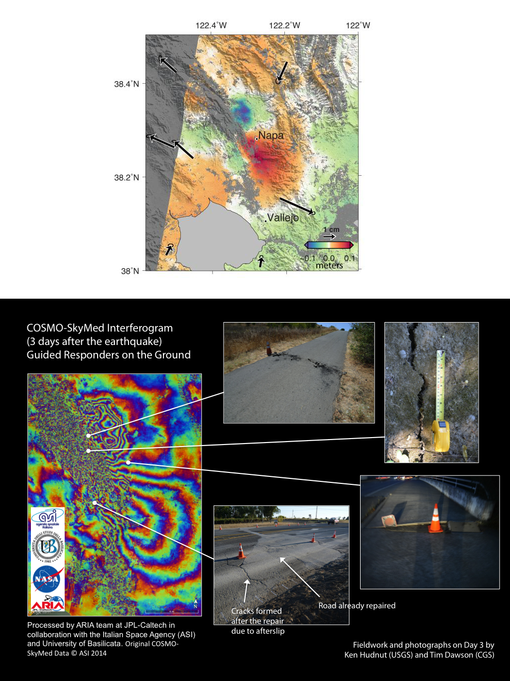
A magnitude 6.0 earthquake struck southern Napa county northeast of San Francisco, California, on Aug. 24, 2014, causing significant damage in the city of Napa and nearby areas. One day after the earthquake, the Advanced Rapid Imaging and Analysis (ARIA) team produced and released observations of coseismic ground displacement measured with continuous GPS stations of the Plate Boundary Observatory (operated by UNAVCO for the National Science Foundation) and the Bay Area Rapid Deformation network (operated by Berkeley Seismological Laboratory). Three days after the earthquake (Aug. 27), the Italian Space Agency’s (ASI) COSMO-SkyMed (CSK) satellite acquired their first post-event data. On the same day, the ARIA team, in collaboration with ASI and University of Basilicata, produced and released a coseismic interferogram that revealed ground deformation and surface rupture. The depiction of the surface rupture – discontinuities of color fringes in the CSK interferogram – helped guide field geologists from the US Geological Survey and the California Geological Survey (CGS) to features that may have otherwise gone undetected. Small-scale cracks were found on a runway of the Napa County Airport, as well as bridge damage and damaged roads. ARIA’s response to this event highlighted the importance of timeliness for mapping surface deformation features. ARIA’s rapid response products were shared through Southern California Earthquake Center’s response website and the California Earthquake Clearinghouse. A damage proxy map derived from InSAR coherence of CSK data was produced and distributed on Aug. 27. Field crews from the CGS identified true and false positives, including mobile home damage, newly planted grape vines, and a cripple wall failure of a house. Finite fault slip models constrained from CSK interferograms and continuous GPS observations reveal a north-propagating rupture with well-resolved slip from 0-10.5 km depth. We also measured along-track coseismic displacements of about -30 to 30 cm, along the main surface rupture, using multiple aperture interferometry and SAR pixel offset calculation. We also processed the European Space Agency’s Sentinel-1A data on Sep. 3 and compared the result with the CSK interferogram, finding a general agreement between the two observations of surface deformation.