Kauring Test Range Airborne Gravity Comparisons using AIRGrav Data Incorporating Measured Horizontal Components
Kauring Test Range Airborne Gravity Comparisons using AIRGrav Data Incorporating Measured Horizontal Components
Abstract ID#: 34418
English Abstract:
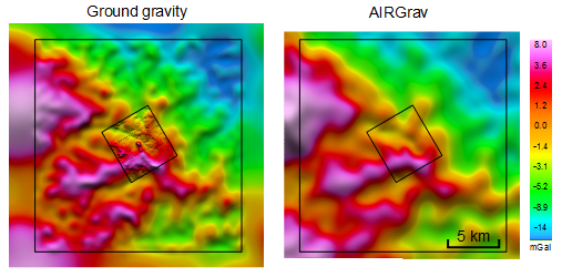
A Sander Geophysics AIRGrav airborne gravity system was flown over Geoscience Australia's Kauring airborne gravity test site in Western Australia. The test site has been very carefully surveyed with land gravimeters for the purpose of making comparisons between airborne gravimetry and gradiometry results and the ground data. The survey area is divided into a 5 km by 5 km inner “AGG” area and a surrounding 20 km by 20 km “AG” area (see figure). Comparisons with both Geoscience Australia ground data over the “AG” area and airborne gravity gradiometer data acquired by CGG using the Falcon system over the “AGG” area are presented. A series of band pass filters of the vertical gravity and vertical gravity gradient are employed to highlight performance at different wavelengths. While the Falcon system is best suited to the shortest wavelengths present at the Kauring test site, the AIRGrav system is also able to resolve relatively short wavelength features. This is due to noise reduction through the oversampling present with tight line spacing combined with the unique characteristics of the AIRGrav system. Horizontal gravity components (or deflections of the vertical) have been obtained from the AIRGrav system using methods that incorporate the latest Australian geoid model. Improved techniques to combine the horizontal components with the vertical to increase vertical gravity accuracy are implemented in the AIRGrav data presented here.