Operational products, based on satellite-forced model, to support marine debris search in the North Pacific.
Jan Hafner1, Nikolai A Maximenko2, Luca Raffaele Centurioni3, Mary Crowley4, Linsey Haram5, Andrey Shcherbina6, Gregory Ruiz5, James T Carlton7 and Cathryn Murray8, (1)IPRC/SOEST U. of Hawaii, Honolulu, HI, United States, (2)University of Hawaii at Manoa, Honolulu, HI, United States, (3)Scripps Institution of Oceanography, University of California San Diego, La Jolla, United States, (4)Ocean Voyages Institute, Sausalito, CA, United States, (5)Smithsonian Environmental Research Center, Edgewater, MD, United States, (6)Applied Physics Laboratory University of Washington, Seattle, United States, (7)Williams College, Mystic Seaport Program, Mystic, CT, United States, (8)PICES North Pacific Marine Science Organization, Sidney, BC, United States
Abstract:
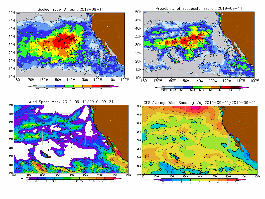
Recently, the impacts of marine debris on the ecosystem and, consequently, the importance of ocean cleanup operations is increasingly recognized both by the community.With the ubiquitous presence and large total amounts, the concentration of marine debris is low and spotting even large objects is often difficult because of rough ocean conditions, with surface waves blocking the view and turbulence mixing debris down.No existing observing system is capable of monitoring marine debris in the open ocean, so we synthesize our model with satellite data to make the best currently possible guess. Our SCUD (Surface CUrrents from Diagnostic) model combines near-real time data of sea level anomaly, mean dynamic topography and wind to produce surface currents consistent with movement of drifting buoys. Model coefficients are optimized locally using historical data.
Exact sources of debris are not known but majority of it remains in the ocean long enough to forget its origin. We force our model with continuous tracer source from all shorelines and we cycle it until the model solution saturates according to the ocean dynamics. Daily maps of concentration of marine debris are then developed for the North Pacific Ocean. These maps represent the probability that debris is present in the particular region, however, rough ocean conditions may reduce chances of successful search. To estimate these chances, we introduce a visibility function that describes how probability of detecting an object decreases with distance from the ship and at higher wind. The visibility mask combined with tracer concentration produces the map of probability of successful search for marine debris.
Using the Global Forecast System, we also produce a 10-day search maps and help to plan successful operatons by guiding then to optimal sites. These recommendations were successfully implemented by many expeditions, including those led by the Ocean Voyages Institute, Algalita, The Swim, etc.