
Advancing Ocean Satellite Data into Research, Applications, Information and Decisions: NOAA Coastwatch/Oceanwatch/Polarwatch
Advancing Ocean Satellite Data into Research, Applications, Information and Decisions: NOAA Coastwatch/Oceanwatch/Polarwatch
Abstract:
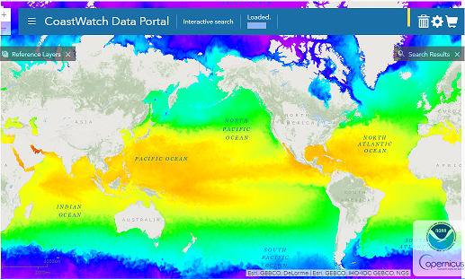
The National Oceanic and Atmospheric Administration (NOAA) CoastWatch/OceanWatchPolarWatch (a.k.a. “CoastWatch”, https://coastwatch.noaa.gov) exists to facilitate the understanding, managing and protecting ocean and coastal resources and for assessing impacts of environmental change in ecosystems, weather, and climate through the use of ocean satellite data in applications and research. Ocean coastal and inland water observations from space have the advantage of broad spatial and temporal coverage that complement in situ measurements. NOAA CoastWatch’s products and services are free and open to government, academic, commercial and general public users. Environmental parameters include sea/lake surface temperature, ocean (water) color (chlorophyll, etc.), sea surface height (altimetry), winds, surface roughness (synthetic aperture radar), salinity and sea ice with global, regional and even high resolution “local” geographical coverage. Data quality and availability are fit for purpose such as near real-time latency as well as delayed-mode, higher quality and longer term time series datasets Organized with our “hub” having the primary processing responsibilities and co-located with the ocean satellite environmental data record (i.e., Level 2) producers at NOAA and our “spokes” being regional Nodes distributed geographically in the US and across NOAA mission line offices, CoastWatch is well-positioned to connect observations with users. Interactive data portals enable search and discovery, multi-product visualization and customizable data downloading. “Power users” can use command-line scripts to automate their access. The OceanWatch Monitor enables the assessment of data products over time and in comparison with reference datasets. CoastWatch teaches training courses, develops tutorials and maintains a helpdesk to educate and guide users from novice to expert. The CoastWatch Utilities software package allows users to customize visualization and analysis. The latest tools, services and products will be presented.
Back to: Operational Satellite Oceanography I