Mapping of Small-scale Ocean Features Using Both SAR and Sea Surface Temperature Data with Machine Learning
Benjamin Holt, Jet Propulsion Laboratory, Pasadena, CA, United States, Brian Bue, Jet Propulsion Laboratory, California Institute of Technology, Pasadena, United States and Jinbo Wang, NASA Jet Propulsion Laboratory, Pasadena, United States
Abstract:
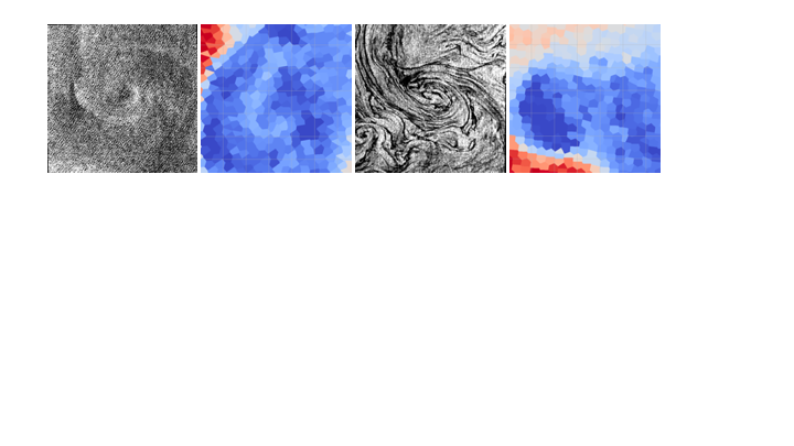
Small ocean eddies (less than ~30-40 km in diameter) are ubiquitous in the coastal margins of the global oceans and the polar seas, but remain largely unquantified for their role in ocean circulation, mixing, and dissipation due to the lack of broad-scale in-situ observations. Small eddies may appear as spirals or as more fully developed, circular features. Fine resolution sensors including SAR (~30 m pixels) are able to capture small eddies in great detail via surface roughness (~1-40 km diameter). Sea surface temperature (SST) fields (~1 km pixels) are able to detect small eddies down to ~5-10 km. Both SAR and SST may observe the same eddies near-coincidentally, over a more limited range of scales (~5-40 km). Limitations exist in both types of sensors, including cloud cover with optical sensors, and surface winds plus non-daily sampling rate with SAR, that may prevent eddy detection, let alone near-coincident detection. Currently, observing and mapping small eddies with SAR relies on visual feature detection followed by mapping of characteristics (location, rotation, diameter), a tedious manual process. Algorithms exist to identify eddies with SST using temperature gradients but not necessarily in terms of shape. With the steady stream of both SAR and SST imagery from multiple sensors, more efficient techniques are called for to enhance the utility of these growing data sets in studies of ocean circulation dynamics and mixing, particularly on these smaller-scales, such as defined as an objective of the SWOT mission.
In this study, we will show early results of applying machine learning methods to identify small eddies observed on the same day by both radar imagery from Sentinel-1 SAR and sea surface temperature data from Sentinel-3, within the coastal zone of California and Baja California. Based on a small dataset consisting of ~500 20km2 subimages extracted from SAR and SST acquisitions spanning roughly one year, we demonstrate our approach is capable of discriminating subimages containing manually-identified eddies from subimages lacking any observable eddies. We also demonstrate that combining SAR and SST eddy detection models both improves detection accuracy and provides higher confidence predictions in comparison to SAR-only or SST-only eddy detectors.