Reconstruction of incomplete spatial data with feature preserving information transport
Reconstruction of incomplete spatial data with feature preserving information transport
Abstract:
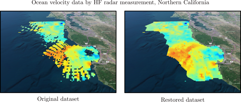
Remote sensing of oceanographic data often yields incomplete coverage of the measurement domain. This can limit interpretability of the data and identification of coherent features informative of ocean dynamics. Several methods exist to fill gaps of missing oceanographic data and are often based on projecting the measurements onto basis functions or a statistical model, such as unweighted least square fitting, empirical orthogonal functions, variational interpolation and open boundary modal analysis. Herein, we use an information transport approach inspired from an image processing algorithm. This approach restore gaps in data by means of advection and anisotropic diffusion on data features as opposed to the field itself. Since this method does not involve fitting or projection, the portions of the domain containing measurements can remain unaltered, and the method offers control over the extent of local information transfer. This method is applied to measurements of ocean surface currents by high frequency radars which the data coverage are often be sporadic. The accuracy and robustness of the method are tested, and the results demonstrate that even for large percentages of missing data points, the restored velocities have errors within the native error of the original data. Results were relatively insensitive to model parameters, facilitating a priori selection of default parameters for de novo applications. We have developed a web-based tool for ocean's data restoration that is publicly available online (http://transport.me.berkeley.edu/restore), and we demonstrate a practical application with online HF radar data.