Monitoring Land Based Sources of Pollution over Coral Reefs using VIIRS Ocean Color Products
Monitoring Land Based Sources of Pollution over Coral Reefs using VIIRS Ocean Color Products
Abstract:
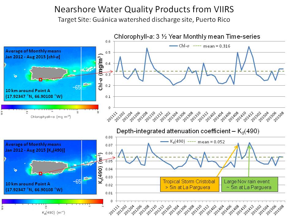
NOAA's Coral Reef Watch (CRW) program and the NESDIS Ocean Color Team are developing new products to monitor land based sources of pollution (LBSP) over coral reef ecosystems using the Visible Infrared Imaging Radiometer Suite (VIIRS) onboard the S-NPP satellite. LBSP are a major threat to corals that can cause disease and mortality, disrupt critical ecological reef functions, and impede growth, reproduction, and larval settlement, among other impacts. From VIIRS, near-real-time satellite products of Chlorophyll-a, Kd(490), and sea surface temperature are being developed for three U.S. Coral Reef Task Force priority watershed sites - Ka’anapali (West Maui, Hawai'i), Faga'alu (American Samoa), and Guánica Bay (Puerto Rico). Background climatological levels of these parameters are being developed to construct anomaly products. Time-series data are being generated to monitor changes in water quality in near-real-time and provide information on historical variations, especially following significant rain events. A pilot calibration/validation field study of the VIIRS-based ocean color products is underway in Puerto Rico; we plan to expand this validation effort to the other two watersheds. Working with local resource managers, we have identified a focal area for product development and validation for each watershed and its associated local reefs. This poster will present preliminary results and identify a path forward to ensure marine resource managers understand and correctly use the new ocean color products, and to help NOAA CRW refine its satellite products to maximize their benefit to coral reef management.
NOAA - National Oceanic and Atmospheric Administration
NESDIS - NOAA/National Environmental Satellite, Data, and Information Service
S-NPP - Suomi National Polar‐orbiting Partnership